Although possible to do this walk from the road, it would be a long day. By far the easiest option is to get a boat in and we regularly use Nick Ingledew for this - he will be able to advise of details and knows the area really well, indeed he discovered one of the principal sites!
The walk takes in a variety of archaeological sites (3D Models of many of which can be found on the Bagh Moraig page) and is set in truly remote country. The going underfoot is rough and can be boggy and as a consequence the walk will take of the order of three or four hours including stops to look at the sites, even though it is probably only a distance of six kilometres.
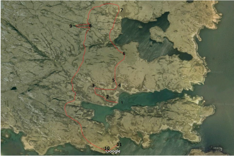
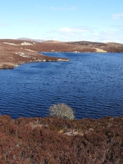
The walk is described for someone landing at Bagh Moraig (1) and departing from the Old Inn site (11). A pdf of the walk to print can be found here.
As you arrive in Bagh Moraig, in front of you is a small hilltop and this is one of the main sites. Before you reach it however, you cross an area cultivated with lazy beds and just above that a row of three or four rough houses (2), the one on the N being the best preserved. In amongst them is a small circular structure, the purpose of which is unclear but is almost certainly associated with agriculture.
You should then aim for the grassy "path" that leads up to the hilltop via a huge block of stone. There are the remains of at least two buildings on this path and the one to the W of the huge block has an interesting niche in it. On the huge block by this structure you can make out marks on the rock which are probably left by knife sharpening.
The walk takes in a variety of archaeological sites (3D Models of many of which can be found on the Bagh Moraig page) and is set in truly remote country. The going underfoot is rough and can be boggy and as a consequence the walk will take of the order of three or four hours including stops to look at the sites, even though it is probably only a distance of six kilometres.
The walk is described for someone landing at Bagh Moraig (1) and departing from the Old Inn site (11). A pdf of the walk to print can be found here.
As you arrive in Bagh Moraig, in front of you is a small hilltop and this is one of the main sites. Before you reach it however, you cross an area cultivated with lazy beds and just above that a row of three or four rough houses (2), the one on the N being the best preserved. In amongst them is a small circular structure, the purpose of which is unclear but is almost certainly associated with agriculture.
You should then aim for the grassy "path" that leads up to the hilltop via a huge block of stone. There are the remains of at least two buildings on this path and the one to the W of the huge block has an interesting niche in it. On the huge block by this structure you can make out marks on the rock which are probably left by knife sharpening.
|
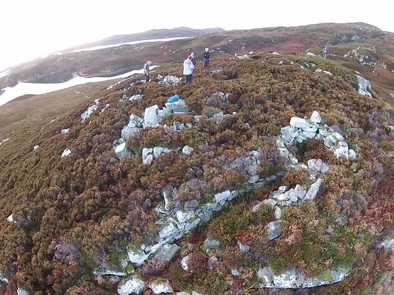
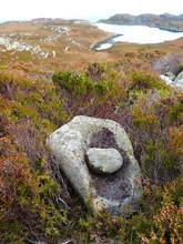
Climb then to the hilltop (3) and look at the various remains. Do be careful where you walk as the ground is full of holes and rocks that move! There is also a big drop to the N. Although reused over many years, several elements of the original Iron Age site are visible, the most obvious of which are the passages on the NE corner along with the saddle quern stone sitting on the surface. These have recently been interpreted as Iron Age souterrains |
|
|
Leave the hilltop back down E towards the shore and keep to the N of the small bay. Just after joining the shore cut up N and there are two rock shelters, where the natural boulders have been adapted to form a shelter (4). The upper contains shells from a previous meal. These sites are difficult to age - it could have been used in the 20th century, it could have been 5000 BC! |
|
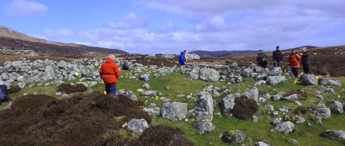
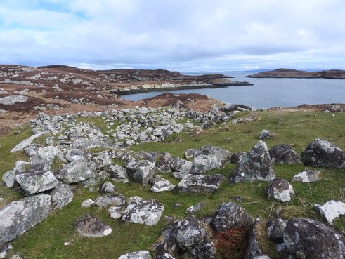
Keep on up and away from the shore and you reach a small heathery plateau at the back of which you can see the remains of a farmstead (5). The most obvious building is built on an older building visible underneath at the S end. There are signs that the whole area has been inhabited from prehistory. The arc of a circular wall on the E edge of the site is probably the best indication. To the right you can see the archaeological surveyors are assessing the site.
|
|
Head N, past a curious but natural cleft in the rocks and find a good route N across a flat boggy area aiming for a slight rise. From this rise (6) you can see the dun in the loch to the right The dun is probably medieval and served more as an enclosure than a dwelling.
Straight ahead you can see your next site, a couple of ruined buildings (7). Find the best route to these buildings. You can just see them on the image to the left at the top left. This settlement was created in 1769 and its inhabitants included the bard, John MacCodrum although the settlement did not last long. Again the site is probably built on a prehistoric remains. There is a medieval mortar bowl reused in one of the walls of the W building and allegedly somewhere is a stone roughly carved C DRUM. If you find it, do please send us a photograph so we can locate it!
Straight ahead you can see your next site, a couple of ruined buildings (7). Find the best route to these buildings. You can just see them on the image to the left at the top left. This settlement was created in 1769 and its inhabitants included the bard, John MacCodrum although the settlement did not last long. Again the site is probably built on a prehistoric remains. There is a medieval mortar bowl reused in one of the walls of the W building and allegedly somewhere is a stone roughly carved C DRUM. If you find it, do please send us a photograph so we can locate it!
|
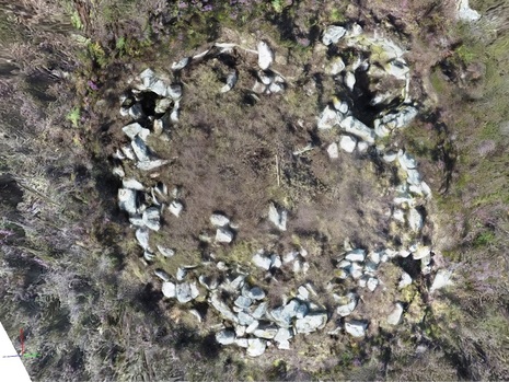
From here you head up the hill to the W - the best route is to head N for a short section to reach the crest and follow this up to the W. When the ground flattens out, head S and you end up in a little valley between the main mountain and a rise of the left. Start going down and you will arrive at a circular pile of stones (8). These stones are the remains of a round house with a few more recent alterations made to it. Probably dating to the Iron Age, it is a good example of its type. If you are feeling energetic, the grassy ramp to the W goes up to a cave that has been used by man in the past (9). |
|
You then need to contour around the hill to towards the S until you have passed the end of Bagh Moraig. Then in the distance, on the shore to the SE you should see a grassy area on a small knoll. This is the Old inn site (10) . Find the best route to it.
The Old Inn is thought to have started life as an Inn for the Dutch fishing fleet in the 17th century. It is mentioned in a poem called An Sgiobaireachd by the bard Archibald MacDonald, known as Gille na Cotaig. He lived between c1750 and c1815. The relevant verse is translated as:
When we came to Rubha Eubhadh (the headland by the Inn)
Every distress went
When we got a full glass.
That would put life into a dead man.
You might wish it were still open!
It also became a landing place for the postal package service until the mid 19th century.
This is where the boat can pick you up.
