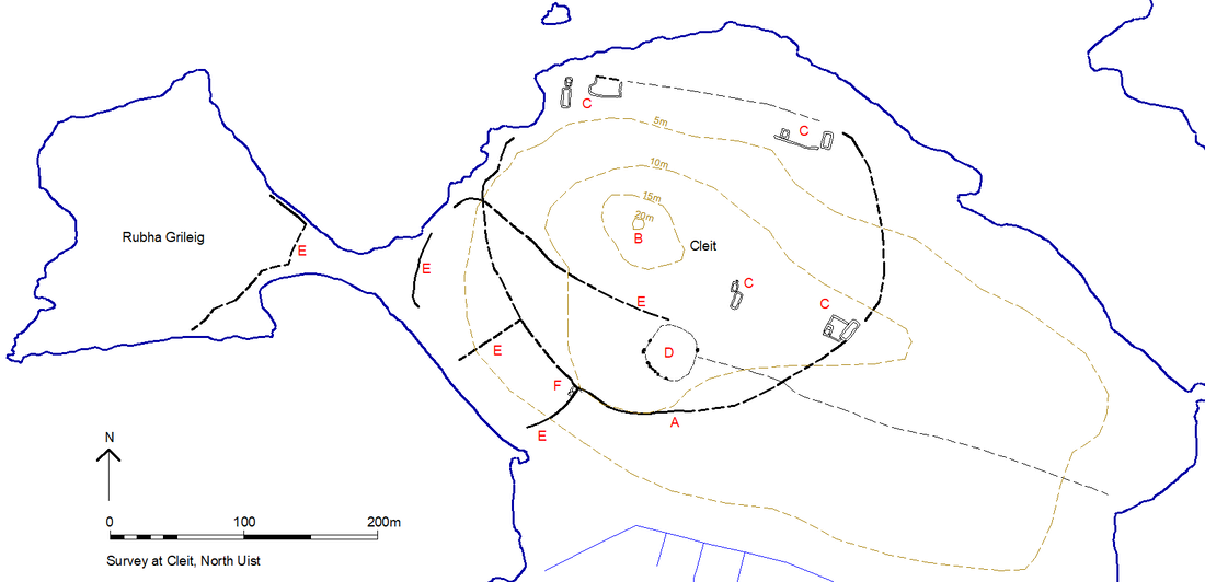
Cleit, Orasaigh NF 85201 74727
This site was first spotted on Google Earth. It is a bigger and more complex site than our other ones. Imagery below reveals a circle of nearly 300m diameter but with a smaller circular enclosure contained within the southern section of the larger one. The larger circle surrounds a prominent outcrop reaching 20m above sea level, the possible site of a dun, Canmore 10344.
the Canmore entry of the OS is however limited: 'There are slight indications that the peninsula of Clett, facing the island of Oransay, may have been once occupied by a dun. Source: E Beveridge 1911. Not located.'
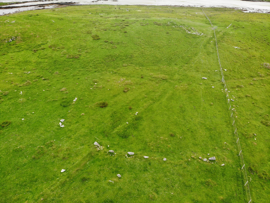
The image at the top of the page is of the ring feature on the southern edge of the circle.
the Canmore entry of the OS is however limited: 'There are slight indications that the peninsula of Clett, facing the island of Oransay, may have been once occupied by a dun. Source: E Beveridge 1911. Not located.'
The image at the top of the page is of the ring feature on the southern edge of the circle.
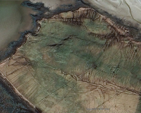
The image below is an historic Google Earth images and is included as it better shows the smaller ring to the S.
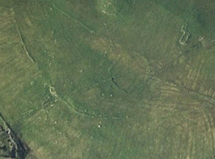
The image below is the western edge of the smaller inner circle. One of North Uist's berst examples of what surveyors onh tiree call a Dragon's Tooth' dyke.
The above is a droner image of the smaller subcurcle enclosure.
The DES entry submitted in 2021 reads as follows:
The Cleit peninsula on North Uist is located on the north shore of the 19th century crofting township
of Ahmor. In the 18 th century the area was grazing land for the nearby tidal island of Orasaigh which
is listed in the 1718 judicial rental for North Uist, and is believed locally to have originally been part of the
late medieval terung of Borerary.
Pre-survey inspection of satellite imagery of the area above suggested that the central area of the
peninsula may have been enclosed by a sub-circular dyke and this was confirmed by later field
survey (A in plan below).
The peninsula is dominated visually by a 20m high rock outcrop at NF 8518 7475 (B in plan below), which
Erskine Beveridge believed might have been the site of an Iron Age dun (Canmore 10344), although
there is no evidence for this on the ground.
Today the landscape is dominated by the remains of abandoned 19 th century crofts - their
boundaries (which clearly overlie dyke A) and their associated farmsteads (C in plan below). It seems very
likely that stone from dyke A was quarried for their construction, as evidenced by three of the four farmsteads lying on the dyke.
The survey showed that the enclosure bounded by dyke A measured between 250 and 300m in
extent and had an area of around 5.5ha. The dyke construction varied considerably and included all
turf, turf and stone and all stone sections. Its dimensions were also variable, with the best
preserved section along its southern sector comprising a substantial turf and stone bank which has
an external face of up to 2m high in places (image at top). Later cultivation has removed a good deal of the
dyke’s northern section, although its route can still be traced with occasional remaining sections of
slumped bank. It appears that sea erosion has removed a section on its north-west side which has,
in part, been rebuilt further inland.
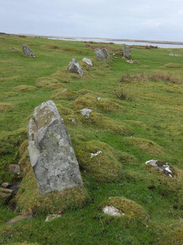
A second, much smaller, sub-rectangular enclosure is located within the larger towards its southern
edge D in plan below). This is part defined by a number of larger field boulders planted upright (above) and
has internal dimensions of between 32 and 37m. A number of other sections of dyke (E in plan below) both
abut and cut cross dyke A. These all appear to post-date the latter, although that separating the
attached peninsula of Rubha Grileig to the west may be contemporary. At the junction of dyke A
and one of the later dyke sections is a two compartment hut of unknown date.
Other sub-circular enclosures and folds have been recorded on North Uist, with a noteworthy group
of four located north-east of the modern township of Bayhead (Canmore 330613 and 330614).
However, these are known to be cattlefolds of 19 th century date and none has a larger dimension
greater than 100m.
This presents the possibility that the much larger Cleit enclosure, which clearly pre-dates the North
Uist land re-organisation of 1814, not only comes from a different period, but also had a different
purpose.
The DES entry submitted in 2021 reads as follows:
The Cleit peninsula on North Uist is located on the north shore of the 19th century crofting township
of Ahmor. In the 18 th century the area was grazing land for the nearby tidal island of Orasaigh which
is listed in the 1718 judicial rental for North Uist, and is believed locally to have originally been part of the
late medieval terung of Borerary.
Pre-survey inspection of satellite imagery of the area above suggested that the central area of the
peninsula may have been enclosed by a sub-circular dyke and this was confirmed by later field
survey (A in plan below).
The peninsula is dominated visually by a 20m high rock outcrop at NF 8518 7475 (B in plan below), which
Erskine Beveridge believed might have been the site of an Iron Age dun (Canmore 10344), although
there is no evidence for this on the ground.
Today the landscape is dominated by the remains of abandoned 19 th century crofts - their
boundaries (which clearly overlie dyke A) and their associated farmsteads (C in plan below). It seems very
likely that stone from dyke A was quarried for their construction, as evidenced by three of the four farmsteads lying on the dyke.
The survey showed that the enclosure bounded by dyke A measured between 250 and 300m in
extent and had an area of around 5.5ha. The dyke construction varied considerably and included all
turf, turf and stone and all stone sections. Its dimensions were also variable, with the best
preserved section along its southern sector comprising a substantial turf and stone bank which has
an external face of up to 2m high in places (image at top). Later cultivation has removed a good deal of the
dyke’s northern section, although its route can still be traced with occasional remaining sections of
slumped bank. It appears that sea erosion has removed a section on its north-west side which has,
in part, been rebuilt further inland.
A second, much smaller, sub-rectangular enclosure is located within the larger towards its southern
edge D in plan below). This is part defined by a number of larger field boulders planted upright (above) and
has internal dimensions of between 32 and 37m. A number of other sections of dyke (E in plan below) both
abut and cut cross dyke A. These all appear to post-date the latter, although that separating the
attached peninsula of Rubha Grileig to the west may be contemporary. At the junction of dyke A
and one of the later dyke sections is a two compartment hut of unknown date.
Other sub-circular enclosures and folds have been recorded on North Uist, with a noteworthy group
of four located north-east of the modern township of Bayhead (Canmore 330613 and 330614).
However, these are known to be cattlefolds of 19 th century date and none has a larger dimension
greater than 100m.
This presents the possibility that the much larger Cleit enclosure, which clearly pre-dates the North
Uist land re-organisation of 1814, not only comes from a different period, but also had a different
purpose.