Just below the summit of Bheinn a Chiaidh on Bearneraigh is the "King Stone." There was a stone on Islay about which Martin Martin wrote "There was a big stone of seven feet square, in which there was a deep impression made to receive the feet of Macdonald; for he was crowned King of the Isles standing in this stone, and swore that he would continue his vassals in the possession of their lands, and do exact justice to all his subjects: and then his father's sword was put into his hand. The Bishop of Argyll and seven priests anointed him king, in presence of all the heads of the tribes in the isles and continent, and were his vassals; at which time the orator rehearsed a catalogue of his ancestors, etc." Some think that the stone on Berneray is a similar one. Facing south in a hollow, it is in an impressive position.
Above is an image of the stone and a 3D model of the stone can be downloaded here. Help on downloading these models is here.
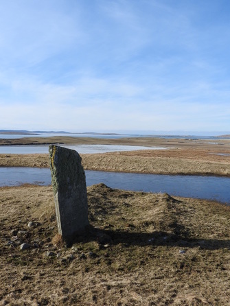
On the summit itself is a sub-rectangular enclosure with structures along the east side and a large standing stone 2.6m tall in the NE sector. Adjacent and W of this stone is a small rectangular building aligned EW. All the components one might expect of an early monastic site.
Around the area are several large stones that appear to be placed rather than natural.
The image above shows the standing stone and the small rectangular building.
The area is called Cladh Maolrithe on the current OS map and is presumably named after Mael Rubha, an Irish monk (643-722) who set up a monastery on the Applecross peninsula and used this as a base for missionary journeys. On the clear day we visited Bearnaraigh the mountains to the north of the Applecross peninsula was clearly visible to our East.
Above is an image of the stone and a 3D model of the stone can be downloaded here. Help on downloading these models is here.
On the summit itself is a sub-rectangular enclosure with structures along the east side and a large standing stone 2.6m tall in the NE sector. Adjacent and W of this stone is a small rectangular building aligned EW. All the components one might expect of an early monastic site.
Around the area are several large stones that appear to be placed rather than natural.
The image above shows the standing stone and the small rectangular building.
The area is called Cladh Maolrithe on the current OS map and is presumably named after Mael Rubha, an Irish monk (643-722) who set up a monastery on the Applecross peninsula and used this as a base for missionary journeys. On the clear day we visited Bearnaraigh the mountains to the north of the Applecross peninsula was clearly visible to our East.
 Blaeu Atlas 1652 courtesy of NLS
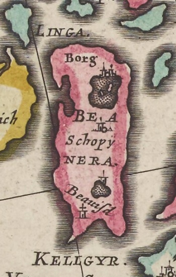
The early mapping of Bearnaraigh was vague until the Blaeu atlas of 1652, probably surveyed around the turn of the 17th century and reproduced to the right.
It seems likely that Pont or Blaeu got Borve (mapped as Borg) and Sheabie (mapped as Schopy) the wrong way around. Beauisd on the Blaeu map is probably Beasdair on the current OS maps.
The four "buildings" on his map are then
- At the W end of the island (probably near the Angus MacAskill memorial) with the northernmost Loch on the map being now partially drained although a lot of standing water remains on the W side of the Borgh machair
- Between Pont's or Baleu's Borg and his Schopy which is perfect for the site on top of Beinn a Chliaidh
- Near Loch Bhrusda
- At Ruisigearraidh presumably adjacent to the old graveyard there, marked on the OS 6" First Series as Cill Aiseam
Martin Martin writes in 1703 "There are two chapels in this isle, to wit, St. Asaph's and St. Columbus's chapel. There is a stone erected near the former, which is eight feet high, and two feet thick."
