This walk explores the Bagh nam Feadag (Bay of the Plover) area of Grimsay. Although close to the road, it does have a wild feel along with impressive views across to Eaval. It has been an under-recorded part of the Uists with only Dun Ban marked on the OS maps.
The main features are Iron Age with a wheelhouse and a dun but there is also evidence of more recent activity, particulary of the kelp industry.
The total length of the walk is of the order of 4 km and should be completed in 90 minutes. Low tide and wellingtons make the walk easier but without them, the ground is not too difficult.
The walk starts at grid reference NF 863 572.
Heading from the North take the first left off the main spine road on Grimsay just as you arrive on the island. Heading from the South take the second right off the main spine road on Grimsay, just before you leave the island. Follow this road, past a right turn and then some saltings appear on your right. As you leave the saltings, there is a house to your left and the road rises to the right. Park just after the house but please do not block the drive of the nearby house in any way.
All the land you walk over is private so please ensure that any livestock is not disturbed and no damage is caused.
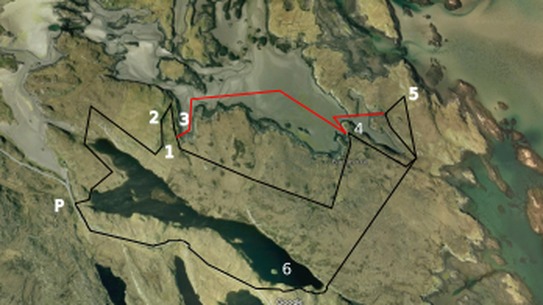
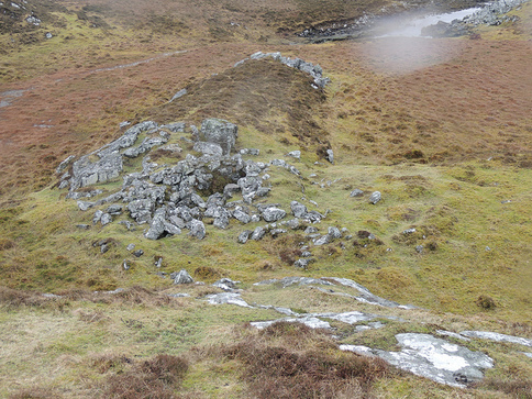
Head away from saltings and over a small rise to the East to see Loch Hornaraigh. Keep the loch on your right until you reach where the stream leaves the loch to head to the saltings. Ahead and to your right, you will see a gate on the rise and head for that, pass through it and keep straight on, keeping on the higher ground. After 200 m and not far before you get to a second fence, the wheelhouse (1) should appear to your left after a little rise. This wheelhouse was excavated by Roy Ashton in the early 2000s and it is slightly controversial with the professional archaeologists as his methods were not totally to their liking.
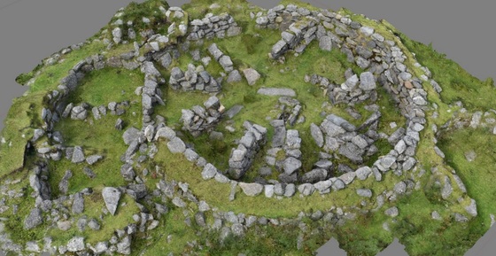
The outermost thin circular wall was constructed by Roy from the debris from his excavation and he is thought to have rebuilt sections of the inner area. However all that said, it is the best wheelhouse on the Uists to help you get an understanding of what these structures looked like.
Built in the Iron Age, wheelhouses consist of a large circular wall with spokes leaving this wall heading towards the centre. The spokes formed individual chambers used for a variety of purposes. In this example the hearth at the centre, with its flue heading E, can be clearly seen. Many sites in Western Isles are used and reused, probably because of the difficulty of obtaining good building stone. In this case 1 m to to the west, you can see the foundations of another circular wall that must have been a previous building. In his excavations, Roy found Viking pottery and so the site was also occupied after the Iron Age.
Local archaeologists recently completed a 3D model of the wheelhouse and a view of this can be seen above.
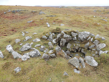
Now leave the wheelhouse and head north parallel to the shore and within 50 metres you come to a mound with several stones on the surfasce (2). This is thought to be a second wheelhouse and is what the excavated wheelhouse looked like before it was excavated. This site also has been re-used altohugh in more recent times to create a shelter or what are often referred to as a shieling hut. It would have been temporary accommodation either for managing the sheep and cattle or for working the kelp.
Going through the gate and following the fence back towards the wheelhouse, on the shore line you will see a jetty (3). Ageing these structures is very difficult and again it is quite possible that is was used for access to the sea for many periods in history.
Going through the gate and following the fence back towards the wheelhouse, on the shore line you will see a jetty (3). Ageing these structures is very difficult and again it is quite possible that is was used for access to the sea for many periods in history.
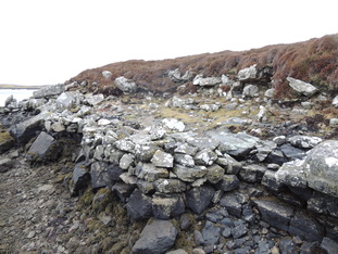
From here you can follow either the black route or more easily, but only possible with a combination of wellingtons and low tide, the red route. On either route, you must decide the precise route you follow. The next site is a well constructed platform along the shore (4). This is almost certainly a platform for landing seaweed. At the turn of the 19th century the burning of seaweed was a crucial part of the economy, allowing the population of the islands to double and for the land-owners to live a life of relative luxury. A change in tax laws in the 1820s stopped the main part of the industry overnight and was a significant factor in causing the clearances, when local inhabitants were forcibly moved off the land.
Following either the black or the red route - again the red route in much easier - head now for a long mound (5). It is 100 m in from the head of a large inlet and is just before the rise. This site is an enigma although the evidence is that there was a circular structure there which probably dated back to the Iron Age which has been re-used in more recent times. The most curious feature is the "inverted staircase" where the circular structure meets the wall cutting across it.
Just to the west of the main structure is a circular depression surrounded by stones.
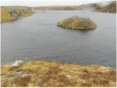
From here head back across the moor towards Loch Hornaraigh and then keeping the loch on your right, climb the rise between the loch and the road and look down on Dun Ban (6).
Just to the west of the main structure is a circular depression surrounded by stones.
From here head back across the moor towards Loch Hornaraigh and then keeping the loch on your right, climb the rise between the loch and the road and look down on Dun Ban (6).
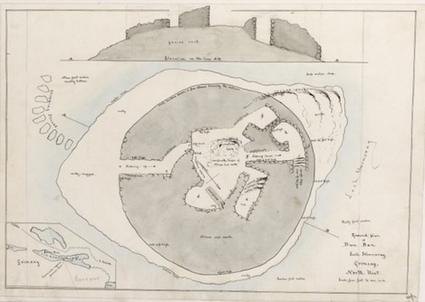
Dun Ban is the one site in this region that is marked on the maps. It was excavated in 1890 by Captain Thomas. It has a causeway curving out to the island. On a clear windy day - you could be lucky - you can just make it out beneath you. It is just visible in the photo below.
On the island Captain Thomas found walls 11 feet thick with a central area surrounded by four "beehive cells". He estimated the height of the original building to be 15 feet tall. An image of his excavated plan can be seen to the right. Some imagination is required now to recreate it from the overgrown mound in the Loch
The precise use of Duns is a matter of much current debate.
The road now is only 50 m in front of you so head to it and then turn right and follow it back to your start point.
If you have enjoyed this walk more information about sites in this area can be found in this document. Also more information about the kelp industry can be found here.
A downloadable and printable pdf of this page can be found here.
If you have enjoyed this walk more information about sites in this area can be found in this document. Also more information about the kelp industry can be found here.
A downloadable and printable pdf of this page can be found here.
